know your springshed
Ginnie Springs
Even if we live far from a spring, the daily choices we make as both private individuals and citizens impact the springs and, ultimately, the quality and quality of water for everyone. In addition, most of us live or work within the springshed of one or many springs.
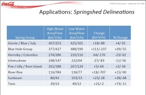
A springshed is an area within a ground or surface water basin that contributes to the spring flow. The boundaries of springsheds are dynamic – they change based on the level of the aquifer (otherwise known as its potentiometric surface). This means that a springshed may cover different areas at different times, depending on whether water levels are high or low.
For example, the Florida Springs Institute estimates that Santa Fe Springshed has shrunk by about 37% – meaning the area that supplies water to the Santa Fe springs, such as Ginnie, has significantly decreased in size, causing reduced spring flow. This change is due, in part, to a declining rainfall trend but increased groundwater pumping is the main culprit.
In Ginnie’s springshed, the larger agricultural and dairy operations have a profound effect on water quality and quantity. Water quality is affected especially in places where the aquifer is unconfined (meaning it’s not completely covered by an impermeable clay substrate). Excess nitrates leaching from waste or fertilizer make their way into the Floridan Aquifer and the rivers, causing abundant algal growth, which chokes the springs and smothers the native vegetation that keeps the spring healthy. In terms of water quantity, agriculture leads the charge in pumping, making up for 40% of the water use in the Suwannee River Water Management District (SRWMD), followed by public supply, which accounts for 35% of the pumping in the district (public water supply refers to water pumped by public or private entities that is then piped to people’s homes and businesses – this is how most people get their water).
See the springshed map to locate where you live in relation to Ginnie or other springs in the area. And check out the links below and the tabs on your right, including “Caring for Your Spring” and “Health and Science,” for more information and tips on ways you can help keep our springs healthy and flowing.
For a more detailed explanation of the Santa Fe and Ginnie Springs springshed, please refer to either of Dr.Todd Kincaid’s presentations on the Florida Springs Institute website.
An excellent resource for information about springs and how to protect them is the Florida’s Springs website. You can also read a more detailed explanation of the Santa Fe and Ginnie Springs springshed, please refer to either of Todd Kincaid’s presentations.
For an interactive tour of how a karst system works, see: . Also watch the legendary Wes Skile’s educational film series The Water’s Journey, available for free here.
For real-time water data (stream stage and stream flow, water quality, and groundwater levels), visit the USGS website.


