know your springshed
Manatee Springs
Most who visit Florida’s springs think of the head pool as the “beginning” of the spring, but in fact the water’s journey begins miles away. Thanks to the porous limestone that makes up the Floridian peninsula, water from rainfall easily percolates through the sandy soils, making small cracks and imperfections ever larger until finally a series of fissures and conduits lead and flow “downhill” towards the rivers and to the sea. There is a complex series of these tunnels and conduits that lead to Manatee Springs.
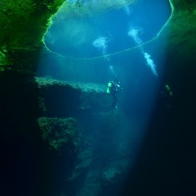
There is an extensive spring cave system that feeds Manatee Springs—over 26,000 feet of mapped passages that have been explored by cave divers. These passages lead to the east of the spring and to the south east toward the town of Chiefland. Dye was released into a sink hole in the city of Chiefland and made its way over 7 miles to the spring in just under 6 days. In the Google Earth photo above, the cave is mapped in orange. Thanks to Brett Hemphill, Andy Pitkin, Michael Poucher and many others for exploring the cave, mapping it and for providing this map. The cave conduit at Manatee has three sink holes that open to the surface from inside the cave. Catfish Hotel Sink, Sue Sink and Friedman’s Sink. Divers can enter and exit the cave from the main spring, Catfish Hotel and Friedman’s Sink. The cave system is HUGE. Here are some photos to give you an idea of what it looks like under the water there…
The surface of the Catfish Hotel Sink is covered with tiny little plants called “duck weed.” It looks almost like you could walk on the surface. The weeds are a tiny vascular plant that consists of two leaves and a root that floats on top of the water. The hole in the center of the weeds is maintained by flow from the cave conduit. The sink hole was formed by the collapse of the cave ceiling into the cave so the water from the conduit flows into one side of the sink hole and out the other which keeps a little of weed cleared away.


