why we love this spring
Ichetucknee Springs
Sacred Blue
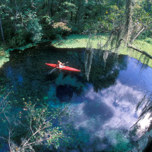
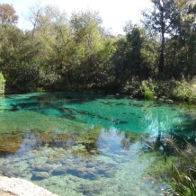
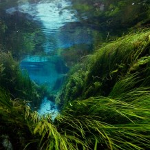
Some people are speechless when they see Ichetucknee for the first time. Others are not. They gasp and smile and whisper reverently and make lyrical sounding remarks in many languages. French people say “Sacre bleu!” I don’t actually know this; I don’t even know if it’s the right context. It just feels right. What blue thing could possibly be more suited to an exclamation that means, “sacred blue?” If I were a French-Floridian, I would say it every time I came here; that or, “aux, my god!”
There’s a mystique about Ichetucknee Springs, an enchantment, which you see in people’s faces when they talk about them. It’s the kind of thing that cannot be understood from written texts, but they are good places to start. As you sit in the parking lot of Ichetucknee Springs State Park scanning through the park brochure just handed to you by the gate attendant, you quickly understand that, aside from those unseen qualities that imbue this place with a sense of spirituality for so many people, it has some amazing qualities that are very apparent to even the first time visitor. These are the kinds of things that make Ichetucknee a must-see site for tourists exploring North Florida.
At the heart of the Ichetucknee system is Ichetucknee River, a six mile stream fed by over a dozen clear, cool springs. A map on the facing page shows the nine named springs dotting the river’s edge like conveniently spaced waypoints along an interpretive trail. They are often compared to jewels on a necklace. Though, I think of them more as charms on a charm bracelet; each with its own, unique story as revealed by their names: Ichetucknee, Blue Hole, Cedar Head, Roaring, Singing (these last two collectively called Mission Springs), Devil’s Eye, Grassy Hole, Mill Pond, and Coffee Springs. That this river and these springs are special places was “officially” confirmed in 1972 when they were designated a National Natural Landmark by the U.S. Department of the Interior. The State of Florida was of a similar mind when it purchased 2,241 acres surrounding the upper four miles of the river in 1970 to create this park.
But, to get a truer sense of what makes Ichetucknee special, it’s worth taking a few moments to consider how Ichetucknee and all the other 1000+ springs in Florida, were created. It’s a story worth knowing, because to understand the formation of Florida’s springs is to understand the land of Florida itself.
Creating the Land
For millions of years of its infancy, Florida was a submerged ridge jutting off the North American continent. The shallow sea that covered it teamed with a wildly diverse cast of aquatic life, ranging from some familiar faces of the mollusk and horseshoe crab clans to bizarre creatures that looked more like science fiction than fact. But for all their diversity, these species shared one common trait—they were all mortal. And when they died, their remains rained down and settled on the sea floor. Modern deep-sea explorers describe a “marine snow” of fine bits of decaying sea creatures that falls incessantly to the sea floor. At times it becomes an underwater white-out. Visibility drops to just a couple of feet.
This “snow pack” accumulated and compacted under its own weight for millions of years. The result was a kind of sedimentary rock called limestone. Eventually, the blanket of compacted lim
estone covering the submerged peninsula was 1,000 – 2,000 feet thick in places.
During the Ice Ages of the last 2.5 million years, Florida’s limestone-covered peninsula rose and dipped below the water many times. More accurately, the sea around it rose and fell as the polar ice caps periodically thawed and re-froze. If we could view Florida from space with time elapsing at super speed—say 1,000 years per second—the peninsula would appear to bob in the water like a log in a river. Mark Twain would have called it a sawyer (Tom’s brother Bob?). To the north, continent-sized waves of ice surged out of Canada and then retreated. Ahead of each wave, Florida expanded. The biggest waves—those that reached farthest southward—caused the peninsula to swell to nearly twice its current size. The Gulf coast near Cedar Key, for instance, was about 100 miles west of its current location. Between waves, the polar ice cap shrank and Florida was reduced to a fraction of its present size. At times, the peninsula dissolved into a chain of islands. From this perspective, Florida would appear as a beating heart.
Today, we are on the tail end of the last Ice Age. The climate has been slowly warming for nearly ten thousand years. As a result, sea levels worldwide have been rising at a constant rate of .6 mm per year for thousands of years. However, in the last few decades, that rate has spiked to nearly 3.0 mm per year—five times its natural rise. It’s a slow-motion natural disaster that’s being revealed in coastal areas throughout the world and is especially dramatic on Florida’s Gulf Coast. But that’s a story for another time and place.
Dissolving the Land
The final chapter in the story of Ichetucknee’s creation began during the inter-glacial periods of the Ice Ages, when Florida stood above the sea level. The key element of this story was rain. While most of the rain that fell on the land drained away as runoff in surface streams, a small portion seeped into the ground. There, made more acidic by decaying vegetation, the water reacted with slightly basic limestone and began slowly dissolving it. Eventually, this process of chemical erosion created subterranean pockets and gaps and eventually a vast network of underground channels. It is these underground voids that are responsible for most of Florida’s surface features such as depressions, sink holes, caves.
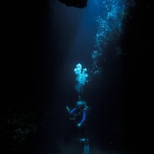
For the most part, this underground system of pockets and hollow rock is known only to cavers and cave divers. However, some components are visible “topside.” When these pockets in the limestone collapse, the ground above them caves-in. This forms surface features such as sink holes and caves. When they collapse into the water table, they form spring pools and flowing springs. It is water from this aquifer that makes up the bulk of water gushing from the springs of Ichetucknee.
The Mid-life crisis in the water’s journey
Having gushed to the surface at the head springs, the water of Ichetucknee’s springs now begins a long overland journey that will eventually carry it to the Gulf of Mexico. The first leg is Ichetucknee River which will carry it for six miles before pouring it into Santa Fe River.
The water that emerges from Ichetucknee springs arrives there by a variety of routes from different directions. Some of it came the slow way, percolating down through the limestone as described above and then merging with the aquifer. Some of that water hasn’t seen the light of day for decades. Some of the water, however, has only been under ground for a matter of weeks. For that water, the route it travelled after hitting the ground as rain and then emerging from Ichetucknee Springs was much more direct.
In Lake City, several creeks disappear into sink holes. Their waters join the underground “rivers” of the aquifer as they course towards their eventual reemergence at the Ichetucknee springs.
This fast-moving underground river is a fascinating element of the complex system of Florida’s aquifers. But, it’s also a troubling one. Florida’s aquifers supply over 90% of the fresh water used by Floridians for drinking and other purposes. So, when we consider that everything that washes into those creeks goes into the aquifer (and, therefore, our drinking water), it becomes apparent that the quality of the water entering the ground is of vital importance to our health. And the threats from pollution don’t end when the water exits the aquifer by way of these springs.
After it leaves here, the water flowing from the Ichetucknee springs begins an 80 mile journey to the Gulf. Along the way, it will pump through the gills, wash the leaves and quench the thirst of every living thing it passes between here and the Gulf of Mexico; it will nurture every aquatic habitat, every swamp, every marsh, and every wetland. Those systems evolved as a result of the water flowing from these springs. They depend on it, not only for their health, but for their very existence. Ichetucknee’s springs aren’t the beginning of the waters journey; nor are they the end. They are a brief moment in the water’s mid-life; a moment that is fast becoming a mid-life crisis.
Wildlife
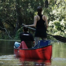
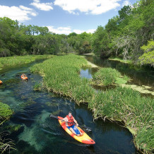
For the first quarter mile, Ichetucknee River’s flow comes entirely from its namesake head-spring. Narrow and winding, this first section threads between 15 foot high walls of limestone. This is beautifully sculpted by chemical and physical erosion for thousands of years. Paddlers are shaded by a high canopy of bald cypress, ash, red maples, hickory and basswood. The understory trees—redbud, Virginia willow, swamp dogwood and salt bush for the most part—are draped with climbing hemp, ground nut and dodder vines. Phoebes, vireos and prothonotary warblers love this area, when they are here.
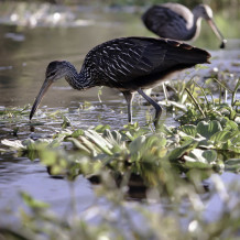
Soon, the high banks move apart and you enter the broad and sunny “rice marsh.” Here, a nice mix of submerged and emergent vegetation (dominated by the namesake wild rice) supports a birders dreamscape. On a normal day, their daily count might easily include white ibis, cormorants, anhingas, wood ducks, wood storks, several species of herons and egrets, American coots, gallinules, bitterns, soras and limpkins. Some summers we spot an occasional roseate spoonbill. When the river level is high, manatees spend time in this area.
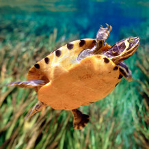
This is also where we start to see more turtles. For many paddlers, the highlight of paddling Ichetucknee is its turtles. Suwannee cooters, yellow bellied turtles and others crowd nearly every large log along the river. Watch the river bottom for dark, fist-sized loggerhead musk turtles. Alligators are scarce.
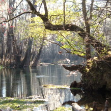
A mile (and several springs) further on brings you into a mature, high-canopied swamp forest of cypress, ash, water oaks, hickory, tupelo, maple and other wetland trees. Pileated woodpeckers, as well as a few smaller members of the woodpecker clan, like this area. Watch for barred owls, red-shouldered hawks, prothonotary and parula warblers and listen for yellow-billed cuckoos, tanagers, and red-eyed vireos.
River otters are commonly seen in all sections of the river. Equally common, though less commonly seen, are beavers. After being trapped out of Florida in the 19th and early 20th centuries, beavers have re-expanded their range. The southern extent of their range is now the Suwannee and Santa Fe River basins (of which Ichetucknee is a part). The fact that they were here before the trappers arrived is confirmed in the river’s name. “Ichetucknee” is a Seminole name meaning, “place of the beavers.”
This is the forest that shrouds the remainder of the river.


